
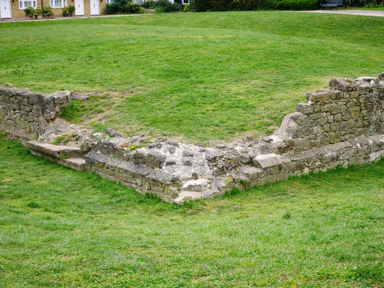
In 1907, a demolition crew clearing a site on the Rotherhithe riverside broke through the fabric of a warehouse and found themselves looking at something that had no business being there. Medieval masonry, six metres high, with four arched window openings on the ground floor and more above them. Not footings. A building, standing, held up inside a Victorian granary like a fossil in rock.
They took it down.
What came out of the ground that year was part of a royal residence, built for Edward III in the years when the Black Death was killing perhaps half the population of London. A portion of it survives. It sits today on a patch of grass at the corner of Bermondsey Wall East and Cathay Street, knee-high and unfenced, passed every morning by people walking to the station who have no idea they are crossing the floor of a king’s hall.
The Hamlet on the Marsh
Rotherhithe in the middle of the fourteenth century was a low, wet, thinly populated place on the wrong side of the river. The ground was alluvial flood plain, drained in patches and liable to go back under when the Thames decided it wanted the land returned. People kept wildfowl and fished and grazed animals on whatever ground stayed firm. There was no dock, no shipyard, no great church.
There was, however, a manor. The first reliable reference comes from 1127, when Henry I granted half of it to the monks of Bermondsey – which means that two hundred years before Edward III took any interest in the place, Rotherhithe already had a manorial identity and an abbey with a stake in it. Bermondsey Abbey runs quietly through this entire story and comes back at the end of it.
The stretch of riverbank now occupied by some of the most expensive flats in south London was, in 1349, somewhere a Londoner went to get out of London.
An island, not a riverbank
The manor did not stand on the bank. It stood on a small island of firmer ground, moated on three sides, with the Thames itself closing the fourth. Everything about the site follows from that arrangement – the way it was approached, what the moat was for, and why the ruins today sit inside a shallow rectangular dip in the lawn, as though someone had pressed a thumb into the turf.
Moated houses of this kind were going up all over England between about 1250 and 1350. The water was rarely a serious military proposition. It was a way of saying who lived there.
The King Who Was Never in One Place
Edward came to the throne at fourteen, in 1327, after his mother and Roger Mortimer deposed his father. He took power for himself at seventeen, in a night operation at Nottingham Castle that ended with Mortimer dragged out through a tunnel and, shortly afterwards, hanged. From 1337 he pressed a claim to the French crown that committed England to a war lasting longer than any English monarch’s reign.
The list of what followed is the reason his name still carries weight. Sluys in 1340. Crécy in 1346, where English longbowmen destroyed the finest heavy cavalry in Europe. Calais taken in 1347 and held for two centuries. The Order of the Garter founded around 1348. And in 1356, his eldest son captured the King of France alive at Poitiers, which is the sort of thing that resets a country’s opinion of itself. By the Treaty of Brétigny in 1360, England held French territory on a scale it would never approach again. Parliament settled into two chambers during the same reign, largely because a war that expensive had to be financed by men who expected to be asked.
None of which explains a small moated house at Rotherhithe. This does.
English kingship in the fourteenth century had no fixed address. The court moved in a near-continuous circuit – Westminster, Windsor, Eltham, Sheen, Havering, King’s Langley, Woodstock – and a monarch was less a resident than a travelling institution that happened to be carrying the government around with it. The houses were the infrastructure of that movement. Seen that way, Rotherhithe stops being an oddity. It was a node: modest, moated, an hour downstream from Westminster by barge, sitting at the very edge of the largest city in the kingdom without being inside it.
Edward was, at the same time, spending money on Windsor at a scale that makes the Rotherhithe works look like a rounding error. The little house was never meant to be important. It was somewhere to be when being somewhere important was inconvenient, or unsafe.
The documented visits run from 1348 to around 1370. Hold that second date.
A King’s House Built in a Plague Year
The moated house was built between 1349 and 1356.
Plague reached London in the autumn of 1348 and the mortality peaked through 1349. So the building accounts and the catastrophe occupy the same calendar, and any account of this site that leaves that out is missing the most interesting thing about it.
Caution is owed here. No document says the manor was built as a refuge from the pestilence, and royal building projects have long lead times that outrun any single emergency – the decision to build may well predate the first case in the city. What can be said without straining the evidence is narrower and, to my mind, more striking. A king needed somewhere to be that was not Westminster and not the City, at a moment when being in either was a reasonable way to die. He had a property downstream, on an island, with water on all four sides and a front door that opened onto the river rather than onto a road full of people. Between 1348 and 1370 he used it repeatedly.
Consider also what it meant to build anything at all in 1350. Labour had become scarce and expensive enough that the Crown legislated to freeze wages at pre-plague levels, twice, and largely failed. Masons could name their price. Carting stone across a collapsing economy to a marsh in Surrey was an act of some determination, and the determination is itself a piece of evidence about how much the king wanted the house.
What the documents describe
A hall. A kitchen. A chapel. A chamber for the king.
There are also references to hawks kept in a chamber, and this is where the standard explanation of the site comes from – no royal hunting park lay nearby, the surrounding marshes were thick with wildfowl, and Edward is known to have been a serious falconer. The reading is plausible and it is repeated almost everywhere the manor is mentioned. It is also an inference. What survives is a mention of birds in a building, and everything built on top of that is ours, not the fourteenth century’s.
Arriving by Water
The inner court was rectangular, about thirty metres by twenty, oriented roughly north to south. Ashlar blocks to plinth level with coursed rubble above, walls between eighty centimetres and a metre and a fifth thick. At the north-west corner, the foundations of a rectangular projection – probably a tower, possibly a gatehouse. South of the moat lay an outer court, where excavation found three stone-lined cesspits, pathways, and what may be the traces of scaffolding. That ground is now underneath a housing development, preserved where it lies.
Here is the detail that reorganises the whole site in the mind. With the Thames forming the open side, the king came downstream by barge on a rising tide and moored at the gatehouse steps. The house had no meaningful relationship with any road. The river was the road, and the river brought you to the door.
Stand on the lawn now and the Thames is behind a wall, on the other side of a path, doing nothing for anyone.
From Royal Hall to Potters’ Yard
After Edward’s death the manor passed to the Cistercian abbey of St Mary Graces, by the Tower. In 1399 St Mary Graces granted it on to Bermondsey Abbey – the same house that had held half the manor since 1127, which closes a loop two hundred and seventy-two years wide.
The Dissolution took it back off them around 1538. By then it was known as “le Mote place”, and the Crown sold it to a man named Robert Lawerde, alias Lord. It went through owners. In the seventeenth century it was leased to two potters, Joseph Muston and Thomas Barnebowe, and the excavations turned up pits of their waste – broken Delftware where the chapel had been. Granaries and warehouses followed in the eighteenth and nineteenth centuries as Rotherhithe turned into a working dock.
At no point does anyone appear to have thought the medieval fabric worth saving. That was not vandalism. On a working riverside a good old wall is a free wall to build against, and building against it is exactly why any of it is still standing.
What the Demolition Men Took Down in 1907
The north wall’s façade was still incorporated into a warehouse in 1907. It had been there the whole time, load-bearing, doing a job.
When redevelopment exposed it properly, the walls were found to stand up to six metres, with four arched window openings on the ground floor and more above. They were demolished.
The date is what stings. 1907 was not some antiquarian dark age – the Society of Antiquaries was in good health, the London County Council had its own survey of the capital’s historic buildings running, and five years later a dealer named George Fabian Lawrence would secure the Cheapside Hoard for the nation precisely because people in that decade understood what they were looking at. A standing fourteenth-century royal building emerged in the middle of all that, and a contractor knocked it down anyway, because the warehouse was the point and the wall was in the way.
What survives, and why it is better than it looks
Excavation came in 1985-7 and again in 1989-91, with further work in 1993 and 1994. The site was scheduled in May 1988.
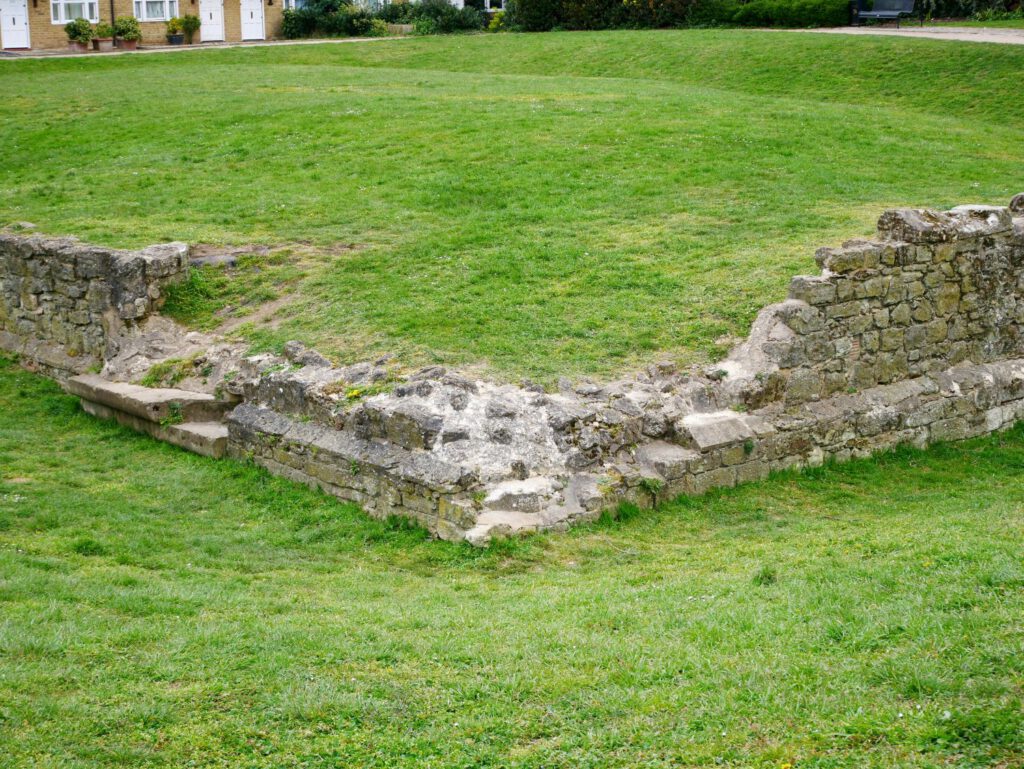
The north wall now stands 3.9 metres, which is ground-floor window-sill level. The east wall reaches about 3.8, retaining the remains of a corbelled window support and a fireplace. The west wall has a small arch in it, probably an outlet for drainage. The south wall was reburied after recording.
Historic England considers survival to sill height unusual in London for a fourteenth-century building of this consequence. The stump we kept, in other words, is remarkable by the standards of this city – and it is a fraction of what a crew with a contract removed in a few weeks of 1907. Underneath it all the diggers found a Late Bronze Age ditch, two Roman pits, and medieval enclosure ditches. People had been using that island for two thousand years before a king wanted it.
Standing on the Site
Come out of Rotherhithe station – Windrush line, and if you approach from the north you arrive through Brunel’s Thames Tunnel, which is a decent way to start a walk of this kind. The Brunel Museum and the original tunnel shaft are immediately there. A minute away is St Mary’s Rotherhithe, where Christopher Jones, master of the Mayflower, is buried. Then go west along Bermondsey Wall East with the river on your right until you reach Cathay Street.
The grass dips. Flint and chalk show through in a rectangle.
There is no gate, no ticket, no opening hours, and nothing that stops you walking straight across the middle of it. The Angel stands a little further along the water, with a terrace out over the foreshore, and it is the busier attraction by a wide margin. You will have passed three well-marked sites to reach the oldest thing on the route, and the oldest thing has the least to say for itself.
A king slept here while his capital was burying its dead in pits, and the walls came up to sill height and stopped because a demolition crew had a contract to finish in 1907. The river that was its front door now runs behind a wall. The house is a shape in a lawn in Southwark, permanently open, permanently free, and almost permanently empty.
