The Neolithic Forest At Purfleet

Beneath the waves of the Thames Estuary, just off the shore of Purfleet, Essex, lie the remnants of an ancient woodland, a submerged forest that dates back millennia. The trees and flora, preserved in waterlogged layers of peat, tell a story of the Earth’s shifting climate and how humanity and nature must adapt when the environment changes drastically. This interplay between past and present in Purfleet’s drowned forest may offer insights into today’s climate concerns, as rising sea levels once again threaten coastal habitats and resources.

From Ice to Forest: How the Thames Valley Transformed

Around 10,000 years ago, as the last Ice Age began to retreat, vast glaciers covering Northern Europe and Britain slowly melted, dramatically altering the landscape. As glaciers receded, they left behind glacial deposits, rich soils, and new habitats, leading to the flourishing of woodlands. Once a broad, ice-bound plain, the Thames Valley transformed into a vibrant river valley where forests took root in the rich alluvial soil.

Approximately 6,000 years ago, a climate shift led to more temperate conditions. This shift allowed the Purfleet forest to emerge, with trees like elm, ash, alder, and hazel taking root. The diversity of trees indicates that Purfleet once boasted a healthy, dense forest that likely extended for miles. Researchers estimate that these forests peaked around 4000 BCE, with species thriving along the banks of a then-narrower Thames River.

As the landscape warmed, plants and animals adapted to the valley’s new ecology, with flora like alder thriving in wetter soils and ash occupying higher, drier ground. These environmental zones supported different species, creating a mosaic of biodiversity. For humans, who had entered the Neolithic era by this time, this fertile area would have been a treasure trove for hunting, gathering, and, eventually, early agriculture.

Rising Seas and the Slow Drowning of the Forest

The same warming trend that encouraged this forest’s growth eventually led to its downfall. As the glaciers melted, the massive influx of water caused global sea levels to rise steadily. These processes shaped the Thames estuary itself, with the river expanding as it absorbed these higher sea levels. What was once a valley forest along the banks of the Thames began to see the first signs of submersion.

By 4000 BCE, sea levels had risen enough to encroach on Purfleet’s woodlands. Every tidal surge brought in more water, gradually transforming the forest floor into an intertidal zone. Over time, the dense forest gave way to wetlands, with the sea advancing inland and claiming more land each year. The once-sturdy trees succumbed, unable to adapt quickly enough to the changing water levels. Eventually, this encroaching sea buried the forest under silt, peat, and clay, preserving much of its remnants in anaerobic conditions.

These preserved trees, their stumps still visible at low tide, remind us of the impact that even slight fluctuations in sea level can have on the environment. For scientists, they also represent a near-perfect time capsule of Earth’s climatic past.

The Fate of Nearby Forests: Rainham and Erith

The Purfleet forest wasn’t alone in its fate. Similar forests once thrived along the banks of the Thames at Rainham and Erith, where riverine woods also saw their slow drowning due to sea level rise. These areas, too, were transformed from thriving forests into intertidal zones. At Rainham, preserved remnants of ancient trees share the same history as those at Purfleet, showing a broad mix of oak, yew, and alder species. This similarity between submerged forests across the Thames region suggests a widespread impact of climate changes around the same time.

Such remnants along the Thames provide a regional snapshot of the past and a sense of the once-interconnected woodlands that lined its banks. Each area offers unique insights into how forests respond to the dynamic balance between land and sea. While Erith and Rainham are more frequently studied, Purfleet stands out due to its distinct species composition and how its remnants have been preserved through natural and human-caused sedimentation.

Human Connection to the Thames and the Impact of Rising Waters

For the ancient peoples who settled along the Thames, the forest was more than just a part of the landscape; it was an essential resource. Neolithic communities likely relied on the Thames’s riverine forests for wood, food, and materials. Discoveries of flint tools, stone axes, and pottery fragments suggest that people hunted, gathered, and possibly even lived in or near these forests. This woodland was a physical space and an ecosystem supporting early human culture.

Human groups faced significant environmental challenges as the climate warmed and sea levels rose. These communities likely adapted by relocating or adjusting their living habits to cope with the advancing waters. The loss of forested land due to encroaching tides would have forced these communities to find new ways to obtain resources or travel further inland to find suitable habitats. In this way, the Thames Valley provides an early example of human resilience and adaptability to changing climates.

Over time, as forests like Purfleet’s disappeared beneath the water, early human settlements would have experienced increased pressure on resources. This shift possibly influenced migratory patterns, prompting some groups to move further inland to drier, more secure regions. This environmental push helped shape the distribution of human populations across the region and even influenced cultural evolution as communities responded to ecological pressures.

Lessons for Today: The Past as a Mirror of the Present

The fate of the Purfleet forest offers valuable lessons for the present as modern societies grapple with rising sea levels and climate change. Much like the ancient woodland, today’s coastal regions face similar threats from the encroaching sea. Modern geological studies of submerged forests like Purfleet’s enable scientists to reconstruct past climate conditions and provide essential data on historical sea-level changes. By understanding these ancient shifts, we know how rising tides may reshape modern landscapes, affecting biodiversity and human societies.

With climate models projecting significant sea level increases over the next century, the lessons from Purfleet resonate more than ever. Current coastal erosion patterns show that cities, farmlands, and natural habitats worldwide risk being submerged if global warming trends continue. The example of Purfleet’s slow transformation reminds us that the Earth’s systems are interconnected, and even seemingly minor changes can lead to significant, often irreversible, environmental shifts.

The submerged forest also provides an educational platform for local communities, directly linking to geological and environmental science. Efforts by conservation groups and local councils to preserve and study Purfleet’s forest remains underscore the importance of this ancient site, not just as a relic of the past but as a touchpoint for today’s environmental discussions.

Rediscovering and Preserving Ancient Forests

Interest in sites like Purfleet has grown as scientists and historians continue to uncover the depth of these submerged landscapes. Local organisations have highlighted the importance of these ancient ecosystems, helping to raise awareness about the Thames Estuary’s unique ecological history. Modern preservation efforts seek to protect these sites, not only to understand past climates but also to inspire sustainable practices today. The submerged Purfleet forest is both a scientific resource and a reminder of nature’s power and fragility in the face of climate change.

Through understanding the submerged forest at Purfleet, we glimpse a time when vast woodlands thrived along the Thames—a landscape now changed but not entirely lost. This ancient woodland, preserved beneath the mud, is a powerful reminder of the Earth’s constant change and the delicate balance between land and sea. Today, as coastal regions around the world confront similar threats, the story of Purfleet’s lost forest reminds us that even the most resilient ecosystems are not immune to the impacts of climate change. Our ability to learn from these past changes may very well shape the future of how we, too, adapt to our planet’s shifting landscape.

The Roman House At Billingsgate: A Look At The Daily Life In Roman Britain

The discovery of Roman relics beneath modern London has captivated historians for over a century, unveiling the city’s layered history as it once was—a bustling Roman hub known as Londinium. Among the remarkable finds lies the Roman House at Billingsgate, a rare example of Roman domestic life in Britain. This ancient dwelling gives us a glimpse of everyday life in a city dominated by traders, soldiers, and artisans, and it stands out as one of the few Roman sites that reflect the city’s domestic character. Tucked away near the famed Roman Wall and in proximity to sites like the Mitraeum and the Basilica, the Billingsgate Roman House is a piece of the puzzle that sheds light on a mysterious chapter in Londinium’s history.

Discovering the Roman House: A Surprise Unearthed During Victorian Expansion

The story of the Billingsgate House began in 1848 when the City of London was in the throes of a construction boom fuelled by the Industrial Revolution. During the erection of the Coal Exchange building near Billingsgate Market, workers stumbled upon an unexpected and significant discovery. As they dug through layers of London’s past, they uncovered the remains of what appeared to be a substantial Roman building. For the archaeologists who rushed to the site, this was a revelation. Until then, most Roman finds had been accidental, with little done to preserve them, but the Coal Exchange find hinted at something substantial enough to be remembered.

J. B. Brunning, a key figure in local antiquarian circles, recognised the importance of the discovery. Seeing the potential to save this piece of history from obliteration, Brunning advocated for its preservation, making an impassioned case for safeguarding these ancient walls. His efforts were remarkable in an era when the need for modern infrastructure often overshadowed historic preservation. The site was designated for posterity, setting a precedent for future archaeological care in the city.

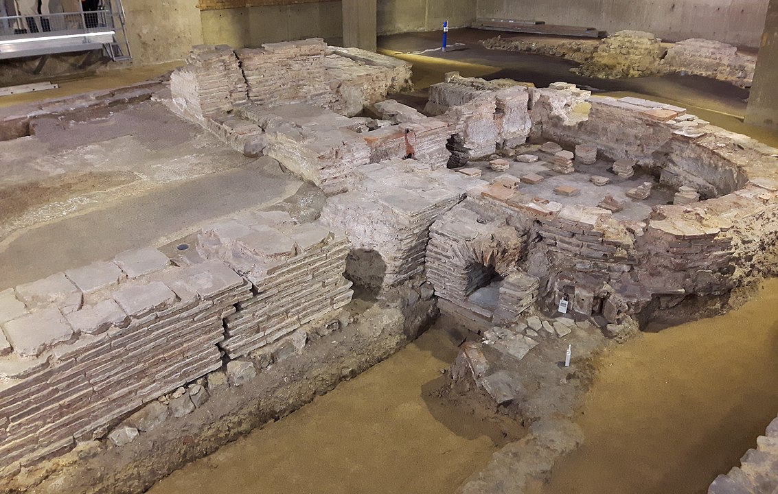
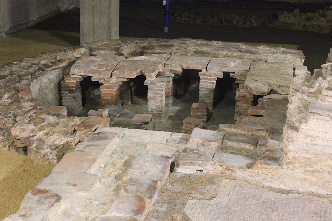
The remains of the Billingsgate Roman bath house date from the 2nd-3rd century AD and were first discovered in 1848 during construction of the London Coal Exchange
By HeritageDaily – Own work, CC BY-SA 3.0, https://commons.wikimedia.org/w/index.php?curid=69196692

Expanding the View: The 1960s Excavations

Despite Brunning’s early attempts at preservation, the Roman House at Billingsgate remained largely untouched until the 1960s, when the archaeological community returned to take a closer look. By this time, the field of archaeology had evolved, and a new generation of archaeologists, using more advanced techniques, hoped to uncover the complete layout of the house and reveal its purpose within Londinium’s Roman society.

Excavations in the 1960s confirmed that this was not just any Roman building but a domus, or private townhouse, belonging to a family of significant wealth and influence. Alongside the main house structure, archaeologists unearthed an adjacent bathhouse—an extraordinary feature hinting at both its inhabitants’ social status and daily routines. The excavation exposed intricate floor mosaics, shards of fine pottery, and remnants of painted walls, which offered a vivid picture of life behind closed doors in Roman London. The bathhouse layout became one of the most distinctive features, boasting all three rooms characteristic of a Roman bath: the frigidarium, tepidarium, and caldarium, each representing a step in the ancient bathing ritual.

Billingsgate Bathhouse
By Carla Brain – Billingsgate Bath House, 23 September 2018 (13), CC BY-SA 2.0, https://commons.wikimedia.org/w/index.php?curid=73279037

The Roman Bathhouse at Billingsgate: A Place of Ritual and Relaxation

The bathhouse at Billingsgate was not just a place for cleanliness but a centre for social activity and relaxation. In Roman culture, bathing was a cherished ritual and a highlight of daily life, blending the practical with the pleasurable. The bathhouse’s design included three main sections, each meticulously constructed to meet Roman standards.

The Frigidarium: This was the cold room, where bathers would typically begin or end their routine. The frigidarium had a plunge pool filled with cool water, a refreshing contrast to the warmer rooms. The room was adorned with mosaic tiles, and traces of painted walls hinted at the attempts to bring colour and artistry into even the most functional spaces.

The Tepidarium: Next came the tepidarium, a warm room that served as an intermediary step, allowing bathers to ease into the process. The room would be filled with steam, keeping bathers warm as they adjusted to the temperature increase. For the Romans, the tepidarium wasn’t just a room; it was a space for mingling, discussing business, and socialising.

The Caldarium: The caldarium was the most heated room, where bathers could immerse themselves in a hot pool. Heated by a hypocaust—a Roman invention that circulated warm air under the floor—the caldarium provided an environment for relaxation and comfort. Oil massages often followed in this room, as slaves or attendants would apply scented oils to enhance the bathing experience. The caldarium also emphasised the wealth and status of the Billingsgate house’s owner; only the affluent could afford a fully outfitted private bath.

This combination of rooms showcased the importance Romans placed on cleanliness, relaxation, and social interaction, a key component of their urban lifestyle. Even within the confines of private homes, the culture of public bathing had its place, bridging personal and communal activities.

A Glimpse of Roman Life on the Thames

The Billingsgate House was located near Londinium’s bustling waterfront, offering its residents a prime spot for both commerce and convenience. The River Thames was the lifeline of Roman London, and properties near the water held high value. The proximity to Londinium’s key landmarks—the Basilica, a hub of administration and commerce; the Roman Wall, which marked the city’s boundaries and protected its citizens; and the Mitraeum, a temple devoted to the god Mithras—suggests that the owners were well-integrated into Londinium’s social and economic fabric.

In this waterfront home, the rhythm of Roman life unfolded against a backdrop of luxury and comfort. Meals would have been elaborate, with imported foods, fine wines, and spices brought in through trade networks stretching across the empire. The house’s artefacts suggest exotic goods, which would have been symbols of wealth and status. Fine tableware, decorative figurines, and jewellery fragments all indicate a family with a level of sophistication that matched the Roman Empire’s cosmopolitan centres.

The Billingsgate House After Rome: A Window Into Post-Roman Britain

The most intriguing aspect of the Billingsgate House is that it appears to have been occupied into the late 5th century AD after the Roman administration formally withdrew from Britain in 410 AD. This fact alone makes the house remarkable. For decades after the fall of Roman authority, this house continued to operate, indicating a gradual, rather than abrupt, decline of Roman culture and influence.

The late 5th-century occupation suggests that the inhabitants might have adapted to the changing times. While the building’s original grandeur may have faded, it is possible that those who lived there held on to the Roman way of life as long as they could, clinging to the customs, architecture, and comforts of a rapidly disappearing past. This continuity challenges the narrative of a sudden end to Roman Britain, suggesting instead a period of transformation where Roman and local traditions may have mingled in unexpected ways.

Eventually, the site was abandoned, its walls and rooms lost to history. Yet, even in this state, the Billingsgate House is a testament to Roman customs’ persistence and the resilience of Londinium’s residents, who faced an uncertain future after centuries of imperial rule.

An Enduring Legacy Beneath the Streets of London

The Roman House at Billingsgate is more than just an archaeological site; it is a piece of London’s identity, connecting the city’s modern pulse to its ancient roots. The excavations at Billingsgate have provided invaluable insights into the private lives of Londinium’s elite while also demonstrating the sophistication of Roman urban living.

Today, visitors can view the ruins of the bathhouse and visualise a world where Romans strolled along the Thames, discussed politics in the basilica, and worshipped in temples devoted to distant gods. The Billingsgate House, preserved for generations to study and appreciate, remains a silent witness to Londinium’s transformation and, ultimately, its enduring spirit. For anyone seeking a closer connection to ancient Roman Britain, these remnants offer a rare and intimate portrait of a city on the cusp of change.

The London Mitraeum: The Quintessential Roman Temple

The London Mithraeum stands as one of the most intriguing relics of ancient Londinium, deeply rooted in the mystery cult of Mithras. Found beneath the modern streets of the bustling city, it provides a rare glimpse into the spiritual lives of Roman soldiers and citizens who called Londinium home in the late third and early fourth centuries. What’s particularly fascinating about the Mithraeum is how it reflects not only the religious practices of its time but also the shifting dynamics between competing belief systems, especially Mithraism and Christianity.

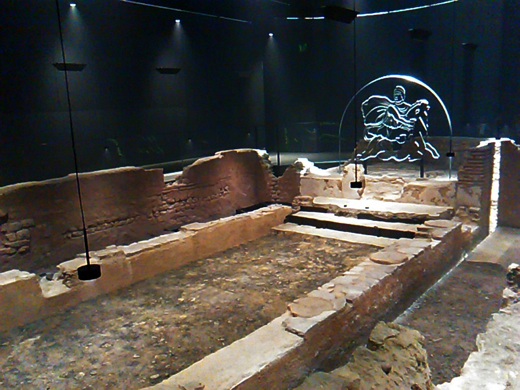
London Mithraeum
By Gapfall – Own work, CC BY-SA 4.0, https://commons.wikimedia.org/w/index.php?curid=65205231

Mithras vs Christ: Competing for the Roman Soul

Mithraism, a mystery cult centred around the god Mithras, enjoyed widespread popularity among Roman soldiers. In contrast to Christianity, which was gaining a foothold among civilians, Mithraism was primarily a male-dominated religion steeped in ritual and exclusivity. Its members, often from the military elite, sought salvation and a connection to the divine through complex initiation ceremonies in secret temples like the London Mithraeum.

Mithras was a deity of light, truth, and loyalty—highly valued by the Roman army. This connection to the military made Mithraism a potential rival to Christianity. While Christianity offered universal salvation and was more inclusive of all social classes and genders, Mithraism appealed to the brotherhood and hierarchy cherished by Roman soldiers. The rituals of Mithraism, including the symbolic slaying of a bull by Mithras (a tauroctony), represented the eternal battle between good and evil, life and death, making it deeply resonant with the values of the Roman Empire.

The competition between these two religions intensified in the late Roman Empire around the third and fourth centuries. Had events played out differently, it’s entirely possible that Mithraism could have become the dominant faith. The religion’s strength among the military meant the backbone of Roman power already favoured it. Christianity, however, ultimately gained the upper hand, mainly due to political factors and imperial support, particularly after Constantine the Great’s conversion.

Mithraism in Late-3rd Century Londinium

Londinium, a thriving Roman city by the late third century, was home to many soldiers, traders, and officials. Mithraism likely arrived with the military, and the construction of the London Mithraeum around this period suggests that the cult was well established within the city. Constantine the Great, who would later become Rome’s first Christian emperor, was initially a follower of Mithras, as was likely his father, Constantius Chlorus. The prominence of Mithraism among the ruling elite lent it considerable influence in the imperial court.

Constantine’s early connection to Mithraism, combined with the popularity of the cult among his soldiers, suggests that had he not converted to Christianity, Mithraism might have risen to dominate the religious landscape of the empire. There’s evidence that Mithraic practices endured even after Constantine’s conversion, but Christianity’s embrace by the imperial family gradually marginalised Mithraism.

In Londinium, the Mithraeum would have served as a place where Roman soldiers and officials gathered to perform sacred rituals, cement their brotherhood, and pledge their loyalty to the empire and each other. The temple was built in the traditional style of Mithraic temples, or Mithraea, which were usually constructed underground to symbolise the cave where Mithras was believed to have slain the sacred bull.

The London Mithraeum: A Glimpse Into the Past

Excavations of the London Mithraeum have revealed much about what this temple would have looked like in its heyday. Built around AD 240-250, the temple was located near the Walbrook River, which once ran through Londinium. Like other Mithraea, it was designed to resemble a cave, with a long, narrow central nave flanked by raised benches where initiates would sit during rituals.

The centrepiece of the Mithraeum would have been a statue or relief depicting the tauroctony—Mithras’s slaying of the bull. This scene was central to Mithraic worship, symbolising the triumph of light over darkness, and was likely the focus of the cult’s sacred ceremonies. Other artefacts discovered during the excavation include altars, votive offerings, and inscriptions dedicated to Mithras, all of which provide insight into the religious practices of the time.

Interestingly, the temple underwent a rededication in the early fourth century, when it was converted into a temple of Bacchus. This change reflects the shifting religious landscape of the time, as Mithraism began to lose its foothold to other cults and, eventually, to Christianity. The rededication to Bacchus, the Roman god of wine and revelry, may have responded to the decline of Mithraic worship, as the Roman elite sought new ways to express their devotion to the gods.

The 1954 Excavations: Uncovering Londinium’s Hidden Past

The discovery of the London Mithraeum was an accident. In 1954, during the post-war reconstruction of London, builders stumbled upon the ruins of the ancient temple while digging foundations for a new office building. The discovery caused a sensation, as it was one of the most significant finds of Roman Londinium to date.

The excavation was led by renowned archaeologists W. F. Grimes and Audrey Williams, who meticulously uncovered the remains of the Mithraeum. Their work revealed the temple’s structure and a treasure trove of artefacts, including statues, altars, and inscriptions. The find was hailed as one of Britain’s most important Roman discoveries, shedding light on a relatively obscure aspect of the empire’s religious history.

However, controversy soon arose over the fate of the temple. In 1962, the ruins were relocated from Walbrook Square to a site near Temple Court as an imperfect compromise to preserve them while allowing for the construction of new buildings on the original site. This decision sparked outrage among historians and the public, who felt that the Mithraeum should have stayed in its original location. Critics argued that the relocation disrupted the temple’s historical context and diminished its significance as part of Londinium’s ancient landscape. In 2010, Bloomberg purchased the Walbrook Square plot and announced its decision to relocate the Mitraeum and restore it to its original look.

The London Mithraeum Today: A Journey Back in Time

Despite the controversy surrounding its relocation, the London Mithraeum remains one of the best places to experience Roman history in the heart of London. In 2017, Bloomberg restored the temple to its original site on Walbrook as part of the Bloomberg European Headquarters development. The reconstruction incorporates cutting-edge technology, immersing visitors in Roman Londinium.

The temple has been painstakingly recreated, complete with dramatic lighting and sound installation that evokes the atmosphere of Mithraic rituals. Visitors descend into the Mithraeum and are transported back in time, experiencing the temple as it would have appeared to Roman soldiers nearly two thousand years ago. The remains of the temple, combined with the artefacts on display, offer a fascinating glimpse into the spiritual lives of Roman Londoners.

What makes the London Mithraeum truly special is its ability to connect visitors with a forgotten chapter of history. Unlike many Roman ruins, which are often reduced to little more than fragments, the Mithraeum has been carefully preserved and presented in a way that brings its story to life. The immersive experience, combined with the detailed archaeological record, makes it a must-visit destination for anyone interested in ancient history.

Why the London Mithraeum Matters

The London Mithraeum is more than just an archaeological site. It reminds us of the complexity of the Roman Empire’s religious landscape and the fierce competition between Mithraism and Christianity during a time of great change. It also speaks to the importance of Londinium as a major Roman city, where soldiers, merchants, and officials from all corners of the empire converged, bringing with them their beliefs, traditions, and gods.

As you stand in the Mithraeum today, it’s easy to imagine the soldiers who once worshipped here gathering secretly to perform ancient rites. You can almost feel the weight of their oaths, hopes for salvation, and loyalty to Mithras. The temple may no longer echo with the chants of Roman initiates, but its walls still tell the story of a time when gods and empires vied for dominance—and a small temple on the banks of the Walbrook was at the heart of it all.

For anyone passionate about Roman history or interested in the rich tapestry of London’s past, the London Mithraeum offers an unparalleled glimpse into a world long forgotten but never truly lost.

The Two Baynard’s Castles: A Tantalising Glimpse At London’s Past

We all know the most imposing structures that remind us of London’s medieval grandeur—Westminster Abbey, the Tower of London, Jewel Tower, Winchester Palace. But there are so many other great buildings we have lost—churches, forts, and townhouses—that have equally fascinating histories to the ones that survived.

Among the lost treasures of this city’s architectural heritage are two buildings that have vanished from the skyline but still linger in legend and lore: Baynard’s Castle. These two structures, built centuries apart, once stood as imposing strongholds, power bases, and settings for some of the most pivotal events in English history. From the Normans to the Tudors, Baynard’s Castle has witnessed it all.

Let’s take a tantalising glimpse at these two Baynard’s Castles and uncover the layers of history, legend, and power they embody.

Baynard’s Castle: The Norman Stronghold

Medieval chronicles suggest the existence of a stronghold at the junction of the rivers Thames and Fleet as early as the reign of Canute the Great. If that is the case, the first Baynard’s Castle might have been rebuilt or reinforced an already existing structure soon after William the Conqueror’s invasion of England in 1066. It was strategically located where the River Fleet flowed into the mighty Thames, just southwest of modern-day St Paul’s Cathedral. This area was a key spot, not just for defence but also for controlling London’s vital river traffic. The Fleet was more of a substantial waterway back then, and Baynard’s Castle guarded this crucial junction.

Ralph Baynard, one of William the Conqueror’s trusted Norman barons and the first Sheriff of Essex, constructed the fortification. A stalwart supporter of the new king, Ralph Baynard was granted substantial land holdings in Essex and London, including the land on which Baynard’s Castle would rise. This Ralph Baynard may well have been the same “Bainardius” mentioned in the Domesday Book, though his exact lineage remains a tantalising mystery.

The Norman castle stood as a traditional motte-and-bailey structure, a wooden keep on an earthen mound. Given its location on the banks of the Thames, it was also well-positioned for riverine defence, securing London’s western flank. Baynard’s Castle would have commanded an impressive view of the river, and its fortifications added to the growing dominance of Norman architecture in a newly conquered England.

But Baynard’s Castle was not merely a fort. Over time, it grew in importance and was associated with some of the most influential families in medieval England, eventually being owned by one of the key figures in the legendary tales of Robin Hood.

Marian Fitzwalter: From Castle Walls to Folklore

By the early 13th century, Baynard’s Castle had passed into the hands of Robert Fitzwalter, a powerful baron and one of the leaders of the Baron’s Revolt against King John. Fitzwalter was a fascinating character, both a rebel and a nobleman, whose life intersected with some of the most famous figures in English legend.

According to folklore, Fitzwalter’s daughter, Marian Fitzwalter, was none other than Maid Marian, the beloved of Robin Hood. Marian the Fair, as she was called, is said to have grown up in the castle, where her beauty and noble spirit captured the hearts of many—including, according to legend, the outlaw Robin Hood. Whether or not this is true, the association between Marian Fitzwalter and Maid Marian has become deeply rooted in England’s folklore. However, it is a historical fact that she caught the eye of no other but King John himself, and his scandalous advances might have provoked the ensuing crisis.

As for her father, Robert Fitzwalter’s rebellion against King John culminated in the Magna Carta’s signing. His leadership in the revolt, however, came at a cost. In retaliation for his disobedience, King John ordered the destruction of Baynard’s Castle. On January 14, 1213, the once-formidable fortress was razed to the ground. The site would remain a ruin for over a century, a silent witness to London’s turbulent past.

The New Baynard’s Castle: A Yorkist Stronghold

In the early 15th century, a new building emerged near the ruins of the original castle, known in the records as a “Hospice called le Old Inne by Pauls Wharfe”. This new Baynard’s Castle, located slightly southeast of its predecessor, near Queenhithe, was less of a defensive fortress and more of a grand, fortified house. It was no longer a Norman outpost but an aristocratic residence.

Baynard’s Castle became particularly significant during the Wars of the Roses, a series of civil wars that gripped England in the 15th century. The Yorkist branch of the Plantagenets used the castle as their London headquarters. During this time, it became a focal point of political intrigue and military strategy. Edward IV, one of the Yorkist claimants to the throne, was known to have gathered his forces there before seizing power. It was at Baynard’s Castle that Edward was proclaimed king, marking one of the most dramatic shifts in English history.

The castle’s new role as a political nerve centre made it more than just an impressive residence. It symbolised the Plantagenet claim to the throne and was a stronghold of legitimacy during the turbulent times of civil war.

Tudor Grandeur and Political Drama

Baynard’s Castle played a vital role in English politics as the Wars of the Roses gave way to the Tudor dynasty. After the victory of Henry VII, the first Tudor king, the royal family repaired and used the house. It was eventually inherited by Henry VIII, who in turn bestowed it upon his first wife, Catherine of Aragon, as part of her dowry. The grandeur and prestige of Baynard’s Castle were undeniable, as it became a key royal residence in the early years of Henry’s reign.

After Catherine’s fall from favour, Baynard’s Castle passed to the Earl of Pembroke, brother-in-law to Henry’s final wife, Catherine Parr. The castle would become a backdrop for some of the most critical events in Tudor politics.

One of the most notable moments in the castle’s history occurred in 1553, during the political crisis that followed the death of Edward VI. Edward, the young Protestant king, had named Lady Jane Grey as his successor, bypassing his Catholic sister Mary. However, this decision proved deeply unpopular. It was at Baynard’s Castle that the Privy Council convened to end Jane’s brief reign and proclaim Mary Tudor as the rightful queen of England. This dramatic shift of power from Protestant to Catholic monarch changed the course of the country’s history, all within the castle’s historic walls.

The Great Fire of 1666: Baynard’s Castle Lost

For all its grandeur, Baynard’s Castle could not escape the devastating events of the Great Fire of London in 1666. Like so many of the city’s landmarks, it was consumed by the flames that swept through London, leaving only smouldering ruins in its wake. The fire, which started in a bakery on Pudding Lane, destroyed much of the city, including St Paul’s Cathedral, and swept west along the Thames. Being so close to the river, Baynard’s Castle was among the many casualties.

London was rebuilt in the aftermath of the fire, but Baynard’s Castle was not. Unlike St Paul’s, which rose again from the ashes, Baynard’s Castle faded into memory, its stones buried beneath the city’s redevelopment.

A Glimpse of What Remains

Today, the legacy of Baynard’s Castle endures in the names of the streets and areas around the site where it once stood. Baynard House, an office block constructed in the 1970s, sits on the approximate location of the original Norman fort, while the surrounding Baynard Street and Castle Baynard Ward further remind the castle’s historical significance.

Though little remains of the actual structure, the stories of the two Baynard’s Castles live on, woven into the fabric of London’s history. From Ralph Baynard’s Norman fortress to the political drama of the Tudors, Baynard’s Castle remains a symbol of the city’s ever-changing landscape—an enduring reminder of London’s past, where legends and history intertwine.

Exploring The Ruins of Lesnes Abbey – A Look At Medieval London

Tucked away in the quiet district of Abbey Wood in southeast London, the ruins of Lesnes Abbey offer a glimpse into the religious, social, and political landscape of medieval England. Once a thriving centre of monastic life, the abbey now stands as a reminder of the country’s shifting tides in history—from its founding in 1178 as an act of penance to its turbulent final years under the weight of political and religious upheaval. This is the story of Lesnes Abbey, an often-overlooked site that played a significant role in London’s medieval past.

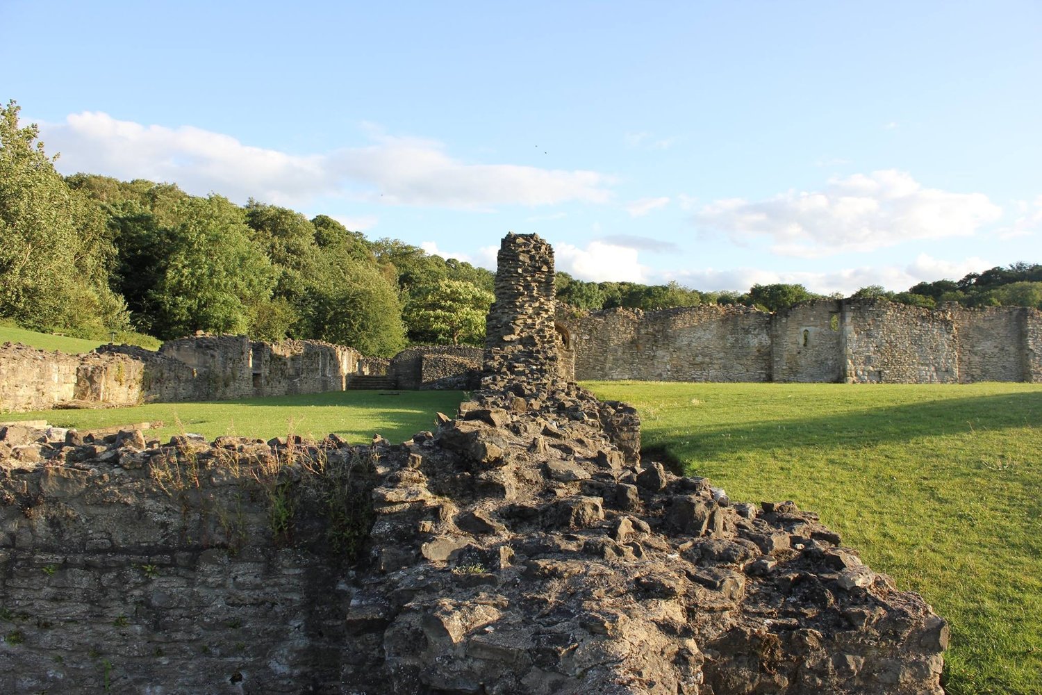
The ruins of Lesnes Abbey, South East London

The Early Years: Founded in 1178 by Richard de Luci

Lesnes Abbey traces its origins to the late 12th century when it was founded in 1178 by Richard de Luci, one of the most powerful men in England at the time. De Luci held the office of Chief Justiciar of England, effectively serving as the king’s right-hand man in judicial and administrative matters. As Chief Justiciar, de Luci was responsible for overseeing the kingdom’s legal affairs, governing in the king’s absence, and ensuring the law was upheld across the land. In short, he wielded immense power.

But Richard de Luci’s career was not without controversy. In 1170, he was implicated in the infamous murder of Thomas Becket, the Archbishop of Canterbury. Becket’s death shocked the Christian world, and though King Henry II was at the heart of the scandal, several of his closest advisors, including de Luci, carried the weight of guilt by association. Some historians argue that the founding of Lesnes Abbey was de Luci’s way of performing an act of penance for his role in the events leading up to Becket’s murder. It was not uncommon in medieval England for the wealthy and powerful to endow religious institutions to secure their place in heaven, particularly when they felt the need for redemption.

The abbey was built as an Augustinian monastery, a fitting choice as the Augustinians were known for their devotion to study, preaching, and pastoral care. Located near the Thames River and surrounded by fertile lands, Lesnes Abbey was well-positioned to thrive spiritually and economically. It was granted estates and lands that provided for its upkeep, and monks lived according to the Augustinian rule, serving the local community and engaging in religious study and prayer.

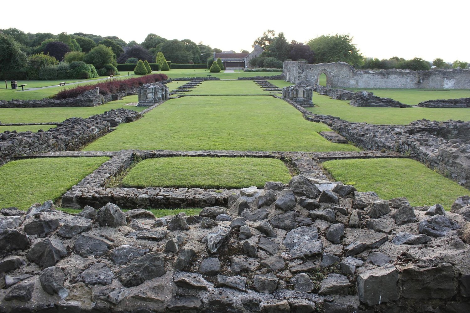
A landscape view of the ruins of Lesnes Abbey

The Turbulent Years: Lesnes Abbey and the Peasant Rebellion

For a time, Lesnes Abbey enjoyed relative peace, but by the late 14th century, the world outside its walls was becoming increasingly turbulent. One of the most significant events that affected Lesnes Abbey during this period was the Peasants’ Revolt of 1381, led by Wat Tyler. This uprising, fuelled by discontent over poll taxes and social inequality, spread like wildfire across England, with peasants targeting religious houses and wealthy landowners who they felt had long oppressed them.

Though Lesnes Abbey was not at the heart of the rebellion, its proximity to London meant it was not immune to the unrest. Abbeys and monasteries were often symbols of both spiritual authority and feudal oppression. For many rebels, these institutions represented the wealth and power they sought to overthrow. The monks at Lesnes, like their counterparts across England, were vulnerable to attack, and though Lesnes Abbey was never ransacked during the rebellion, the threat of violence loomed large. A group of rebels under Abel Ker from Erith forced their way into the abbey and made the abbot swear an oath of allegiance to their cause.

The revolt was quickly quashed, but the social tensions it exposed remained. For Lesnes Abbey, this period marked the beginning of its decline. The economic strain caused by ongoing political unrest and the crown’s increasing financial demands on religious houses meant that Lesnes struggled to maintain its former prosperity.

The Inauspicious Ending: Cardinal Wolsey and the Early Reformation

The final blow to Lesnes Abbey came in 1526, during Henry VIII’s reign. By this time, the winds of change were sweeping through England, and the once untouchable power of the Catholic Church was beginning to wane. At the heart of this shift was Cardinal Thomas Wolsey, the king’s chief advisor and one of the most powerful figures in England. Wolsey had been tasked with reforming the English church, and one of his strategies was the dissolution of smaller, less prosperous monasteries.

Lesnes Abbey, which had already been in financial trouble for some time, became one of the early victims of these reforms. In 1524, it was identified as a “superfluous” institution—too small and poor to justify its continued existence. In 1526, the abbey was officially closed two years later, and the crown confiscated its lands and assets.

This closure was a harbinger of the larger dissolution of monasteries in the 1530s when Henry VIII broke with the Roman Catholic Church and established the Church of England. The Dissolution of the Monasteries saw hundreds of religious houses across England closed, their wealth transferred to the crown and their buildings left to crumble. For Lesnes Abbey, this marked the end of nearly four centuries of monastic life.

The fate of Lesnes Abbey reflects the broader changes taking place in England at the time. The early Reformation years were marked by a shift away from the authority of the pope and the Roman Catholic Church, as Henry VIII sought to consolidate his power and gain control over England’s religious institutions. Many smaller abbeys, like Lesnes, could not survive this turbulent period; their downfall hastened by political and economic forces beyond their control.

Lesnes Abbey Today: A Ruined Reminder of a Lost Past

Today, the ruins of Lesnes Abbey (a Grade II site) stand as a testament to the abbey’s long and complex history. Visitors to the site can explore the remains of the abbey’s church, cloisters, and other monastic buildings, all of which give a sense of the scale and importance of the abbey in its heyday. Though much of the abbey has been lost to time, the site’s layout is still visible, and information boards provide context for those who come to learn about this fascinating slice of medieval history.

One of the most striking aspects of visiting Lesnes Abbey today is the juxtaposition of the ancient ruins with the modern city of London in the background. It reminds us how much the city has changed over the centuries and how its medieval past still lingers beneath the surface.

Lesnes Abbey has also become a popular spot for locals seeking a peaceful retreat from the hustle and bustle of city life. The surrounding Lesnes Abbey Woods provide a tranquil setting for walking and picnicking, while the carefully preserved ruins offer an evocative glimpse into London’s distant past.

Though the abbey is no longer a functioning religious institution, its legacy lives on in the local community and the history books. Lesnes Abbey, from its founding in 1178 to its dissolution in 1526, mirrors the broader story of medieval England—one of faith, conflict, and change.

In many ways, Lesnes Abbey represents a microcosm of the forces that shaped medieval London. From its foundation as a penitent act by a powerful man through the social upheaval of the Peasants’ Revolt to its final dissolution in the Reformation, the abbey’s history offers valuable insights into the political and religious landscape of the time. Visiting the ruins today, it is easy to imagine the monks who once walked its cloisters, their lives shaped by the same forces of power, faith, and politics that continue to shape the world today.

London’s Camelot: The History Behind Barnet’s Long-Forgotten Camlet Moat

What is the most enduring – and beloved – English folklore myth? You don’t have to be a historian to point to King Arthur, Camelot, and the Knights of the Round Table. However, in most cases, the Arthurian legends take us to the western part of the Isles – to Wales and Somerset. London is not a likely place to look for Arthurian clues.

And yet, today, we will take you to the rolling hills of Trent Country Park in the London Borough of Barnet. Just off the beaten path near the summit of Ferny Hill, a mysterious quadrangular moat lies almost forgotten. This site, known as Camlet Moat, has long intrigued historians, archaeologists, and Arthurian enthusiasts. It bears the teasing nickname “London’s Camelot,” inviting fanciful speculation about its origins and purpose. But what is the true history behind this moat, and how did it come to be associated with one of Britain’s most enduring legends?

The Arthurian Myth: A King That Never Dies

The name Camelot conjures immediate associations with the legendary King Arthur, the “once and future king.” For over a millennium, the Arthurian myth has captivated imaginations with its tales of knights, quests for the Holy Grail, and the enduring hope that Arthur will one day return to restore peace to Britain. Arthur, though often considered a figure of folklore, straddles the line between myth and history in a way that few other legendary figures do. His story has been passed down through countless generations, and every generation finds new meaning.

Central to the Arthurian myth is the legendary inscription: Hic iacet Arthurus, rex quondam, rexque futurus—“Here lies Arthur, the once and future king.” This phrase, found on what is purported to be King Arthur’s gravestone, is imbued with a sense of eternal hope. It suggests that Arthur is not truly gone, only waiting to rise again in Britain’s hour of greatest need. This mystical quality of Arthur’s legacy has kept his story alive for centuries.

Many have sought the true Camelot, the fabled seat of Arthur’s kingdom. Numerous sites across Britain claim to be the “real” Camelot, from Tintagel in Cornwall to Cadbury Castle in Somerset. But the allure of Arthur’s myth is not confined to these well-known spots. It has stretched even to the outskirts of London, where a lesser-known contender for Camelot’s crown lies hidden in Barnet. Camlet Moat has been linked with the legendary Camelot through name alone—but is that enough?

Camlet Moat: The Enigmatic Quadrangle

Camlet Moat may not rival the grandeur of some of Britain’s more famous castles, but its tranquil setting and unusual layout make it a fascinating relic of the past. The moat forms a roughly square enclosure, surrounded by earthworks that have long been softened by time and vegetation. Situated near the summit of Ferny Hill, it’s one of those places that feels almost forgotten by modern life yet steeped in a quiet sense of history.

Today, the site lies hidden within the dense woods of Trent Country Park. Visitors can still see the water-filled moat that encircles a central raised platform, hinting at the structures that once stood there. Although any standing buildings have long since vanished, the shape of the moat suggests a fortified manor or small castle. The presence of a wooden drawbridge, revealed by excavations in the 19th and 20th centuries, points to a defensive purpose, though the true extent of its military role remains speculative.

The moat itself is about 60 metres across, forming a near-perfect quadrangle. It would have provided a strong defensive feature in its heyday, isolating the central structure from potential invaders. The elevated platform inside the moat could have supported a manor house, even with small auxiliary buildings. Although the site is now quiet and unassuming, there’s a sense of timelessness here—perhaps it’s the same timelessness that has made some wonder if Camlet Moat could have been linked, however tenuously, with the Camelot of Arthurian legend.

Camlet’s Name: History and Legend Intertwined

The first known mention of Camlet Moat in historical records dates back to 1440 when it was referred to as “the manor of Camelot.” This tantalising name has led to centuries of speculation. Could it have been a direct reference to the Arthurian legend? Or was it simply a corruption of an older, more mundane name that happened to sound like Camelot? The truth may never be known, but the name alone has provided fuel for those who love a good mystery.

Some believe the name Camlet is a distorted version of Camelot, perhaps arising from local folklore or a historical misunderstanding. Others suggest that the name could be related to the Old French word chamelet, which referred to a type of woollen fabric. While this theory is less romantic, it suggests that the area was once associated with trade or craftsmanship.

Yet another theory posits that Camlet Moat’s association with Camelot might have been deliberate, though probably in jest. A speculative hypothesis suggests that a local stonemason, who previously worked at the carving of Edward III’s famous round table at Windsor Castle and owned property in Enfield, jokingly named the Moat “Camelot”. The powerful Plantagenet king wanted to restore the Order of the Round Table, though not much came out of it. The jest, however, stuck.

Whether the name Camelot was bestowed with intention or arose organically, it stuck. And with it, the legend of Arthur has become inextricably linked to the site.

Sir Geoffrey de Mandeville: The Man Behind the Moat?

One of the most intriguing aspects of Camlet Moat’s history is its possible connection to Sir Geoffrey de Mandeville, 1st Earl of Essex and Constable of the Tower of London. Geoffrey was a powerful and controversial figure in 12th-century England, known for his shifting allegiances and ruthless ambition. His name has been tied to various fortifications across the country, and some believe he may have had a hand in constructing the first structures at Camlet Moat.

Sir Geoffrey de Mandeville owned land in the area during the 12th century, a period of great instability and conflict in England. During his lifetime, Geoffrey was a staunch supporter of King Stephen during the period of civil war known as The Anarchy. However, his loyalty was often questioned, and the Church declared him a traitor and excommunicated him. Before his downfall, though, it’s possible that he sought to fortify his holdings in Barnet.

If Geoffrey did build at Camlet Moat, he would likely have constructed a manor house or small fortification, complete with the defensive moat that still exists today. The site’s proximity to Enfield Chase, a royal hunting ground, would have made it a valuable strategic location. Excavations in the 19th and late 20th centuries uncovered evidence of a wooden drawbridge, suggesting that the structure was designed with defence in mind. This, combined with its elevated position on Ferny Hill, points to a site that may have served as a guard post or outpost for nearby estates.

Excavations and Speculation: What Lies Beneath?

Archaeological digs at Camlet Moat have only added to the intrigue surrounding the site. Although no definitive evidence has been found to confirm a direct link to Sir Geoffrey de Mandeville or King Arthur, excavations have uncovered tantalising clues. In the 1880s, the discovery of the wooden drawbridge was made, along with traces of foundations that could have belonged to a medieval manor or fortification.

In the 20th century, further investigations found remnants of pottery and other artefacts dating back to the 14th century, indicating that the site was occupied or used for several hundred years. These findings suggest that Camlet Moat was not a simple farmstead or rural estate—it may have played a role in local defence, especially given its strategic location near Enfield Chase.

The moat’s remote location has protected it from the worst ravages of urbanisation, leaving the site relatively untouched. Today, it stands as a quiet testament to the mysteries of the past, its true history still buried beneath layers of speculation and legend.

London’s Forgotten Camelot

Whether Camlet Moat was ever truly intended to be linked to Arthurian legend or its name is a mere historical quirk, the site remains a fascinating piece of London’s medieval history. As you walk through the woods of Trent Country Park, you can almost imagine the knights of old, the banners fluttering, and the distant sounds of a forgotten age. Though the once-grand manor has faded into the mists of time, the moat remains, its waters still whispering of kings, legends, and long-lost secrets.

In Barnet, London’s Camelot may not boast the grand towers of the legendary Camelot, but it holds its allure—a place where history and myth entwine, waiting for those who seek it.

The Southwark Cathedral: Trying to Unpack the Historical Facts Around the 606 AD Claim

London is a city layered with history, where streets, buildings, and even churches are wrapped in stories of the past. From the monumental Westminster Abbey to the smaller but equally significant churches like St Helen Bishopsgate and St Bride’s, many of these sacred sites carry claims that stretch back over a thousand years. Some of these claims, though, often fall under scrutiny from historians. Southwark Cathedral, for instance, has a long and illustrious history, but the church’s claim that it dates back to 606 AD raises more questions than it answers.

The Problem with London’s Ancient Church Claims

London’s churches are known for their architectural grandeur and rich histories, but they are also known for ambitious historical claims. Westminster Abbey is an iconic example. The current Gothic masterpiece, mostly built between the 13th and 16th centuries, is said to stand on the site of a much earlier church founded by Saint Dunstan in the 960s. Yet, legends insist there was an even older Roman temple dedicated to Apollo on that site. Historical records don’t support such a temple’s existence, but the claim lingers in popular imagination.

Another case is St Helen Bishopsgate, which boasts an impressive history as one of London’s few surviving medieval churches. While claims suggest its origins stretch back to the 10th century, there is little concrete evidence for this early date. The same is true for St Mary-le-Bow, an East End church with a stunning Baroque design that often clings to a history that supposedly stretches into Anglo-Saxon times. Even St Bride’s Church on Fleet Street claims a murky foundation story, with some legends linking it to Roman times, despite the current church being the ninth iteration, dating from Sir Christopher Wren’s post-Great Fire of London reconstruction.

Churches like these are not content with simply being hundreds of years old; they seem to need to push the envelope back even further, as though a church’s legacy requires it to predate the Norman Conquest to truly matter. This brings us to Southwark Cathedral, where a claim of being founded in 606 AD stands out as particularly dubious.

Southwark Cathedral and the 606 AD Claim

Nestled on the southern bank of the Thames, Southwark Cathedral is one of London’s most charming historic churches. It’s no stretch to say that this building has witnessed countless moments in the city’s story. The church has stood as a symbol of religious life in Southwark for many centuries, but did it truly exist in 606 AD?

The official narrative, presented by church authorities, claims that a Christian place of worship has been on the site since 606 AD. However, there is little historical documentation to back up such a precise and early date. This assertion seems based more on local folklore and loose references than solid evidence. The idea that Southwark could have had a Christian church at that time is not impossible, but it remains speculative without any archaeological proof to substantiate it.

Even the oldest parts of the current structure, largely built between the 12th and 14th centuries, provide no clues that point to a 7th-century origin. What is clear, though, is that Southwark was an important area during the Roman and Anglo-Saxon periods, given its strategic location near the river and major Roman roads. Still, no clear evidence has surfaced suggesting a formal church existed before the Norman Conquest.

The Historical Facts: Domesday Book and St Mary Overy

The first historical mention of a church in Southwark comes from the Domesday Book, the great survey commissioned by William the Conqueror in 1086. However, the details are vague. The Domesday entry refers to a church in Southwark but gives no name, location, or indication that it was the precursor to Southwark Cathedral.

More concrete history begins with the founding of St Mary Overy Priory in 1106. This Augustinian priory, established by William Giffard, the Bishop of Winchester, is a key moment in Southwark Cathedral’s history. The priory became a religious and social hub in medieval Southwark, attracting pilgrims and laypeople. By the 12th century, the priory church was likely a grand structure, far removed from the humble beginnings implied by the 606 AD claim.

Even so, some historical writers have hinted at an older church on the site. John Stowe, a 16th-century historian, wrote that a church existed “far before the Conquest in 1066.” But Stowe’s records are vague at best. His claim lacks specific references and appears more based on oral tradition and speculation than tangible evidence. In historical research, unsubstantiated claims, such as those made by Stowe, must be treated cautiously, as they can blur the line between history and legend.

The Search for Proof

Historians and archaeologists investigating Southwark Cathedral have not uncovered much that lends credibility to the 606 AD claim. While some remnants of earlier structures have been found in the area, there is no concrete proof of a 7th-century church. Much of the evidence points to the 12th century as the true foundation period for the current building’s predecessor.

Why, then, does the cathedral insist on this much older date? One answer lies in the tendency of many of London’s historic churches to present themselves as having deeper, almost mythical roots. It creates a sense of continuity and importance that stretches centuries, linking the present building with the earliest days of Christianity in Britain. This is common among churches and religious institutions, where historical grandeur is seen as part of their spiritual and cultural legacy.

The Need to Extend History: Is It Necessary?

The desire to extend the age of historical churches isn’t unique to Southwark Cathedral. Across Europe, churches often make claims that tie them to the earliest periods of Christian history. The question is, why do they feel the need to do so?

In a city like London, where history is everywhere, there seems to be a certain prestige that comes with being older. A church that can claim a foundation in the 7th century may seem more impressive or spiritually significant than one founded a few centuries later. The reverence for ancient history leads to “historical inflation,” where churches feel compelled to push their origins back further than the evidence supports.

But this raises an interesting question: Isn’t the real history enough? Southwark Cathedral, like many of its peers, has a rich and well-documented history stretching back nearly a millennium. The priory of St Mary Overy, the turbulent centuries of religious and political change, the figures who have passed through its doors—all of these elements form a fascinating story. Yet, the desire to be the “oldest” somehow remains irresistible, even when the facts don’t fully align.

Perhaps it is human nature to seek out beginnings. We are often drawn to continuity, the notion that a place has stood witness to countless generations. But in the case of Southwark Cathedral and other historic churches, the real histories – with all their complexities, reconstructions, and evolutions – are just as compelling as the myths that seek to extend them further.

Looking Beyond the Claims

The history of Southwark Cathedral is a testament to the layers of time and belief that shape London’s sacred spaces. While the claim of a 606 AD origin is dubious, it doesn’t take away from the importance of this church as a site of spiritual and cultural life. The real history, from the founding of the Priory of St Mary Overy to its role in the Reformation and beyond, is more than enough to secure Southwark Cathedral’s place as one of London’s great landmarks. Ultimately, the truth is as enduring as the myths – and often just as fascinating.

How To Meet A Blue Whale In London: The Fascinating Story of Barnet’s Whalebones

Encountering a blue whale in open waters is among the most awesome things a person can experience. Seeing these gentle giants glide through the depths puts things in perspective unlike anything else in the world. But seeing a blue whale in London – now that’s something you wouldn’t expect to hear. And yet you can – well, sort of… Let us explain.

A Monument of the Unseen Giants

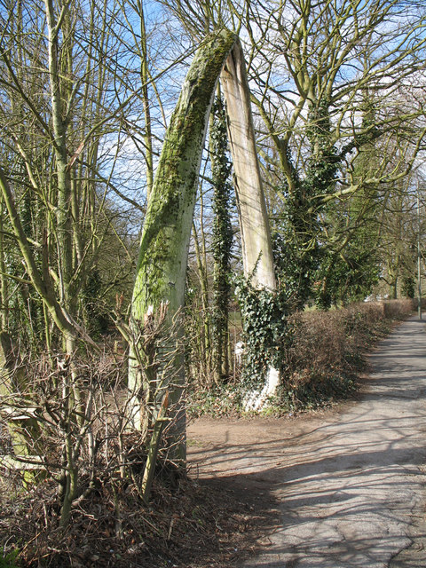
The jawbones of a whale, forming the entrance to Whalebones Park
By Martin Addison, CC BY-SA 2.0, https://commons.wikimedia.org/w/index.php?curid=9252252

If you happen to have some business in the neighbourhood of Barnet, head towards Wood Street. Go past the modest houses and shops, only to encounter the towering arch formed by two enormous whale jawbones. These bones, which once belonged to the largest animal on Earth, now stand in an unexpected spot far from their oceanic origins. The Whalebones landmark has become a familiar sight for locals and an intriguing curiosity for visitors passing through. Standing beneath these bones is a strange, humbling experience. The sheer size of the structure offers a physical reminder of how enormous blue whales are. It’s as if a piece of the ocean had been plucked from the waves and settled in the middle of Barnet.

The jawbones, which reach upwards like a gateway to a world of bygone maritime adventures, have been part of the local landscape for decades. Though they’ve become part of Barnet’s identity, the story of how these whale bones ended here is a tale full of unlikely events and surprising twists.

The Circus Comes to Town: Installing the Whalebones in 1939

The jawbones arrived in Barnet in a lorry via Hull in 1939. The event felt like a grand spectacle, almost like a travelling circus rolling into town. As construction crews prepared to install these enormous bones, a quiet residential area was suddenly abuzz with activity. The bones were sourced from a blue whale and delivered from Norway. However, turning these massive pieces of natural history into a sturdy archway wasn’t simple.

For starters, the bones were not just large but unwieldy. Moving them into position took careful planning, involving the frantic efforts of half a dozen workers. The locals gathered to watch the show as the construction crew manoeuvred these whale bones into place. It was a strange sight – not something you’d expect to see in a quiet London suburb. Children stood wide-eyed as these gigantic bones slowly rose into the air.

The crew had to ensure the bones were stable, balancing their weight and securing them to a strong foundation. The bones were arranged in an arch, reminiscent of the prows of Viking ships or the entrance to a mythical kingdom. To many, it felt like something out of a storybook, a doorway to another world. Once installed, the structure quickly became a landmark. Even today, the sense of wonder remains.

From the Ocean to Barnet: The Origins of the Whalebones

So how did these whale bones end up in Barnet in the first place? The answer lies in the history of a house that stood on Wood Street, a property known as Whalebones. The house was built in 1815, and the name Whalebones first appeared on a map in 1872, and the house had always been something of a local curiosity. While the exact reason for the estate’s peculiar name is shrouded in mystery, many believe it was linked to the house’s most prominent resident – no other than the famous polar explorer, Sir John Franklin. Over time, the property’s name became synonymous with the giant jawbones at the entrance, giving the house an air of exoticism and adventure.

The bones themselves came from Norway. In the 19th century, whale hunting was a massive industry in Norway, where the rich waters of the North Atlantic provided ample opportunity for capturing these giant creatures. The Norwegian company that delivered the bones to Barnet was part of this booming industry. In a world where whaling was still common, exporting such bones was not unusual. However, the idea of using these bones as an architectural feature in a quiet London suburb was unusual. Yet that’s exactly what happened.

The house, Whalebones, remained a prominent feature in Barnet until its eventual demolition in the mid-20th century. But the bones remained a curious relic of the estate and the oceanic giants that once ruled the seas.

A Fight for Whalebones: The Housing Development Controversy

While the bones have stood for decades, their future has not always been secure. In 2019, a major development proposal threatened to change the landscape of Whalebones forever. A housing complex of 152 new homes was proposed for the site, and this plan immediately met with strong opposition from the local community.

Like much of London, Barnet has faced increasing pressure to meet housing demands. Developers often look for large open spaces where they can build new homes. The Whalebones estate, with its expansive grounds, seemed an attractive option for such a project. However, for many in Barnet, Whalebones was more than just a convenient plot of land. It symbolised the area’s unique heritage, a landmark that had stood for generations.

Local residents, conservation groups, and heritage organisations rallied to oppose the development. For them, the Whalebones were not just relics of the past but a crucial part of Barnet’s identity. They argued that the bones and the green space around them must be preserved for future generations. The proposal to replace the bones with a housing complex felt like erasing a piece of history.

The campaign to save Whalebones was fierce and passionate. Letters were written, petitions were signed, and public meetings were held. The message was clear: Whalebones belonged to Barnet and should remain untouched. The debate lasted for months, with both sides presenting their arguments. For the developers, the housing shortage was a pressing concern. For the locals, however, the loss of Whalebones would have been a cultural tragedy.

In 2020, the proposal was officially rejected. The community’s efforts had paid off, and the Whalebones were saved. The jawbones remain standing, a testament to both Barnet’s maritime connections and the power of local action.

Whalebones Today: A Piece of Barnet’s Soul

Today, Whalebones is more than just a quirky landmark. It’s a reminder of Barnet’s long history, a piece of the past that connects the area to the wider world. It also symbolises how communities can come together to protect the places that matter to them.

While the original Whalebones house is long gone, and the area around it has changed, the archway of blue whale jawbones remains a striking and unusual feature. It echoes a time when maritime adventures and exotic discoveries captured the public’s imagination. In an era when London was a hub of global exploration, the idea of bringing something as monumental as whale bones back to the city wasn’t just plausible—it was thrilling.

The Whalebones link the natural world and the urban environment, a meeting point between land and sea. They remind us of the sheer scale of the creatures that inhabit our oceans and the way humans have interacted with them over the centuries. Meeting a blue whale in Barnet might seem impossible, but standing under the Whalebones arch, you’re closer to the giants of the deep than you might think.

Loughton Camp – The Iron Hill Fort

If you love history and outdoor adventures and are looking for a place to escape London’s urban chaos, Loughton Camp is an excellent choice for a weekend family trip. Multiple bus routes can take you there from various spots in London, and the walk up the hill is worth it. But why Loughton Camp? We will tease you with two names – Julius Caesar and Boudica. If you want to know more, read on!

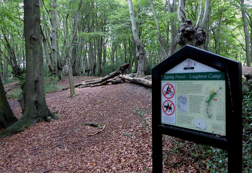
Northwestern bank of Loughton Camp with information board
By User:Ethan Doyle White, CC BY-SA 4.0, https://commons.wikimedia.org/w/index.php?curid=61850510

Loughton Camp: Location and Topology

Loughton Camp is situated within the ancient woodland of Epping Forest in Essex, just to the northeast of London. This part of the forest is characterised by a striking mixture of tall, old trees and dense undergrowth, offering an almost mystical atmosphere to the visitor. The hill fort is perched on a high plateau, roughly 90 metres above sea level, giving it a commanding view of the surrounding landscape. This elevation, one of the highest points in the forest, makes it an ideal natural fortification.

The camp is relatively large, encompassing approximately 4 hectares (about 10 acres), and is ringed by a series of shallow banks and ditches that would have been much deeper and steeper in its prime. These defences form an oval shape, with the interior likely having been used for settlement, livestock, and storage. Walking along the site today, one can still discern these earthworks despite the natural erosion and overgrowth that have softened their edges over the centuries. The proximity of Loughton Brook, a small stream, would have provided an essential water source for the inhabitants.

Earliest History – The Trinovantes’ Settlement

Loughton Camp dates back to around 500 BC, during the late Bronze Age or early Iron Age. Archaeological finds, including pottery shards and iron tools, suggest that it was inhabited by the Trinovantes, one of the most powerful tribes in southeastern Britain at the time. The Trinovantes controlled much of modern-day Essex and parts of Suffolk and were known for their metalworking, farming, and trade skills.

The exact purpose of Loughton Camp remains a topic of debate among historians and archaeologists. Given the size of the fort and its robust earthwork defences, it is likely that it served as a communal living area for several hundred people. The site would have been a centre for the surrounding agricultural community, providing a secure place to retreat in times of conflict. Given its proximity to the navigable River Lea and its strategic position overlooking key routes through the forest, it may also have functioned as a trading hub.

Unlike some other hill forts of the period, which show signs of continuous occupation, Loughton Camp has been intermittently used. This could suggest that it was primarily a seasonal or emergency site, only inhabited when the local population felt threatened by rival tribes or external invaders.

A Natural Stronghold – The Strategic Position

The placement of Loughton Camp atop one of the highest points in Epping Forest was no accident. From its vantage point, the camp would have provided an exceptional lookout over the surrounding countryside, making it an ideal location for surveillance and defence. The forest itself would have acted as a natural barrier, making it difficult for large forces to navigate quickly, which added to the site’s defensibility.

In Iron Age Britain, hill forts were often built in such commanding locations for military reasons and as a symbol of tribal power. Loughton Camp’s elevated position would have allowed its inhabitants to monitor movement along ancient trackways that passed through the forest and the nearby valleys. Any approaching danger would be spotted well in advance, giving the residents time to prepare or retreat if necessary.

The earthwork fortifications would have further strengthened this natural defensive position. The steep slopes surrounding the camp would have made it difficult for attackers to storm the site, while the banks and ditches would have slowed down any assault. Loughton Camp was undoubtedly a formidable stronghold in its day, with its back protected by the dense forest and its front offering a clear view of any advancing enemy.

The Controversy – Caesar’s Third Camp or Boudica’s Last Stand?

Loughton Camp’s history is not without controversy. One theory, proposed by enthusiast historian Roger Nolan, suggests that Loughton Camp might have played a role in Julius Caesar’s second invasion of Britain in 54 BC. According to Nolan, Loughton Camp could have been Caesar’s third camp, used during his campaign as he pushed inland from the Kent coast. The idea is intriguing, though it remains speculative due to the lack of direct archaeological evidence linking the site to Roman occupation.

Caesar’s invasion, which was largely aimed at securing tribute from the British tribes and preventing them from aiding his Gallic enemies, involved several skirmishes and temporary camps as his forces marched through the southeast. The theory posits that Loughton Camp’s strategic location and proximity to the River Lea could have made it a suitable site for a temporary Roman encampment during the campaign. Yet, this remains a fascinating but unproven suggestion without concrete artefacts like Roman pottery, coins, or weapons.

Local legends also link the campsite to Boudica’s war against the Romans in 60-61 AD. The rebellion, led by the warrior queen of the Iceni tribe, was a major uprising against Roman rule. Boudica’s forces attacked Roman settlements across eastern England, including Londinium (modern-day London), before being defeated by Roman legions. With its advantageous position, some believe that Loughton Camp could have been used as a campsite or rallying point for Boudica’s forces as they moved through the region.

Again, this theory is pure speculation. No archaeological finds from the Roman period have been uncovered at the site, and Boudica’s movements during the rebellion are still largely unknown. While it’s tempting to imagine Loughton Camp playing a role in these dramatic events, these ideas remain unconvincing for now.

Loughton Camp Today – A Quiet Remnant of the Past

Today, Loughton Camp is a peaceful, often overlooked part of Epping Forest, far removed from its past’s potential conflict and intrigue. Visitors can walk among the ancient earthworks, marvelling at how nature has slowly reclaimed this once-defended position. The site is a popular spot for walkers and history enthusiasts, offering a glimpse into the region’s ancient past while providing a quiet retreat from the modern world.

Epping Forest is a place of great natural beauty, home to diverse flora and fauna. The surrounding woodland remains much as it would have appeared to the ancient inhabitants of Loughton Camp, with towering oaks and hornbeams providing a canopy that has stood for centuries.

Though much about the site remains a mystery, Loughton Camp’s history as an Iron Age hill fort is undeniable. Whether it played a role in Caesar’s invasion or Boudica’s rebellion may never be known for certain. Still, its position and construction speak of a place valued for its natural strength and strategic significance.

In visiting Loughton Camp, one steps back into a world where the hills and forests were picturesque landscapes and vital fortifications, where ancient tribes stood in the shadow of the encroaching Roman Empire. The mysteries of Loughton Camp continue to inspire curiosity and wonder, a reminder that even the quietest corners of our history have stories to tell.

The Hidden Secrets Beneath St Bride’s Church at Fleet Street

If you happen to stroll along Fleet Street, you will surely notice St Bride’s Church’s famous wedding cake spire, designed by England’s most notable architect, Sir Christopher Wren. However, few know you can visit one of the most fascinating and blood-chilling archaeological sites under the church. Featuring a fragment of a Roman paved street, the foundations of Saxon and mediaeval Christian temples, and a haunting charnel house, it is a must-visit for those tempted by London’s millennial history.

From its ancient roots as a possible site of 6th-century worship to its repeated destruction and rebirth, St Bride’s is a microcosm of London’s turbulent life. And it is what lies beneath its foundations that reveals the layers of its fascinating, and at times eerie, past.

The Early History of St Bride’s Church

St Bride’s Church may be best known for its striking spire, but its origins stretch back far beyond Sir Christopher Wren’s baroque creation. Archaeological evidence suggests that a place of worship existed on this site as early as the 6th century AD, when London, or Londinium, was a relatively quiet town in post-Roman Britain, a mere shadow of its former urban glory.

It is believed that the earliest church here may have been a simple wooden structure built by early Saxon Christians. Fleet Street was part of an ancient Roman road that connected the heart of Londinium with the surrounding areas, making it a vital location for commerce, communication, and religious life.

Over time, the early wooden church would have been replaced by more substantial structures as the city grew and developed. By the medieval period, St Bride’s had become a prominent place of worship for the growing population of Londoners. Its name is thought to derive from St Brigid, a patron saint of Ireland, and the church would have served as a spiritual anchor for the inhabitants of Fleet Street and beyond.

The Great Fire of London and Christopher Wren’s Masterpiece

The Great Fire of London in 1666 consumed much of the city, and St Bride’s was not spared. The wooden structure that had stood for centuries was reduced to ashes, along with 87 other churches. But from this catastrophe emerged one of the greatest architectural minds of the time, Sir Christopher Wren.

Wren, tasked with rebuilding many of the city’s churches, approached the reconstruction of St Bride’s with the same ingenuity and grandeur that marked his work on St Paul’s Cathedral and other masterpieces. The church’s most famous feature, the spire, was designed as a symbol of hope and resilience. With its layered design resembling a wedding cake, it became a lasting icon of the city.

Like many of Wren’s works, St Bride’s reflected the blend of elegance and practicality that defined his architectural style. While St Paul’s Cathedral may have been his crowning achievement, St Bride’s spire is one of his most creative expressions. The church was designed to be more than just a place of worship—it was a statement of London’s capacity for renewal.

The Cholera Outbreak of 1854 and Sealing of the Tombs

St Bride’s continued to serve as a hub for its parishioners well into the 19th century, but another disaster would soon touch it. In 1854, an outbreak of cholera swept through London, causing widespread panic and devastation. This particular outbreak became infamous for its connection to the contaminated water supply around Broad Street, but it also affected those buried beneath St Bride’s.

The cholera epidemic forced authorities to reassess the practice of burying people in church crypts and graveyards, particularly in urban areas like Fleet Street. It was feared that decaying bodies in the church’s tombs could be spreading disease through the air and water. As a result, many of the tombs at St Bride’s were sealed to prevent further contamination.

These tombs, once the final resting places for some of London’s notable citizens, remained untouched for nearly a century. It wasn’t until much later, during the reconstruction after World War II, that they were reopened, revealing chilling secrets of the church’s past.

The Blitz and the Excavations That Followed

As Londoners endured the harrowing days of the Blitz during World War II, St Bride’s found itself again in the line of fire. In December 1940, a bomb hit the church, reducing it to ruins for the second time in its history. Though the spire survived, the interior was obliterated, leaving only a skeleton of Wren’s vision.

Before the church could be rebuilt, archaeologists were granted permission to conduct excavations beneath the ruins. What they uncovered shocked many and offered a rare glimpse into the ancient history of London.

The excavation of St Bride’s unearthed layers of history buried beneath its foundations. Beneath the rubble of Wren’s baroque masterpiece, archaeologists found traces of Roman Londinium, Saxon artefacts, and medieval foundations, each representing different periods of the city’s evolution.

The Roman Ditch and Pavement

One of the most remarkable discoveries during the excavation was the remains of a Roman ditch and pavement. The Roman presence in the area dates back to the 1st century AD when Londinium was an important Roman settlement. The excavation revealed the remnants of a Roman road and a drainage ditch that would have helped channel water from the higher ground towards the River Fleet.

The discovery of the Roman pavement was particularly significant, as it provided a tangible link to the city’s ancient past. This well-preserved section of Roman engineering underscored Fleet Street’s long-standing importance as a major thoroughfare, long before it became synonymous with London’s printing trade.

Saxon and Mediaeval Foundations

As archaeologists dug deeper, they uncovered foundations from the Saxon and Mediaeval periods, each offering insights into the church’s evolving architecture. The earliest were believed to be from the 6th or 7th century when the first Christian structure was built on the site.

Later, mediaeval foundations showed how the church expanded and rebuilt over the centuries. These remnants of previous iterations of St Bride’s reminded us of the constant flux of history—the church, like the city it served, had been built, destroyed, and rebuilt countless times.

The Iron Coffin of Mrs Campbell

Among the many tombs discovered beneath St Bride’s, one stood out as particularly curious: the iron coffin of Mrs Campbell. Unlike the more traditional lead or wooden coffins, Mrs Campbell had been interred in a large iron sarcophagus, likely as a precaution against grave robbers.

The coffin, while fascinating from an archaeological perspective, also raised questions about Mrs Campbell’s life and death. Iron coffins were rare and expensive, typically reserved for those who could afford such elaborate burials. The decision to place her in such a coffin suggests a concern about the sanctity of her final resting place, possibly due to the fear of body-snatching, a practice not uncommon in 18th—and 19th-century London.

The Blood-Chilling Charnel House

Perhaps the most macabre discovery beneath St Bride’s was the charnel house, a place where bones of the dead were stored after their bodies had decayed. This grim chamber was filled with human remains, carefully stacked in a manner that reflected both the practicalities of space and the reverence for the dead.

The charnel house was a reminder of the church’s medieval past when burial space in London was at a premium. Instead of leaving decaying bodies in overcrowded churchyards, remains would be exhumed and placed in charnel houses to make room for new burials. While the practice may seem unsettling today, it was a common solution to the problem of limited burial space in urban areas.

The discovery of the charnel house beneath St Bride’s brought to light the sobering reality of life, death, and burial practices in medieval London. It was a testament to the church’s long history as a place of worship but also of burial and remembrance.

A Church with a Thousand Lives

With its elegant spire towering over Fleet Street, St Bride’s Church is more than just a symbol of architectural beauty. It is a history repository containing the stories of centuries beneath its foundations. St Bride’s is a microcosm of the city’s life story from its Roman origins to its Saxon beginnings, its medieval transformations, and its role as a final resting place for London’s dead.

The hidden secrets beneath St Bride’s remind us that London’s history is written in the buildings we see above ground and the layers beneath.